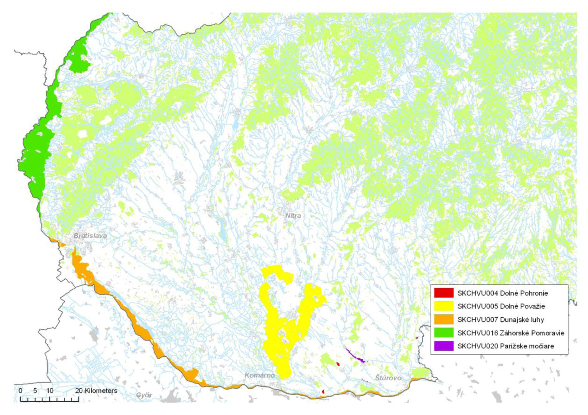
Project area

Project area consists of 5 Special Protection Areas (SPAs) belonging to the European system of protected areas Natura 2000:
There is lot of loess and sandy walls in this sub-site situated on natural terraces or in mining areas, which are surrounded by agricultural land and forest. SPA Dolné Pohronie consists of four independent parts located in eatern Podunajská nížina. All of the four parts are localized in the area of aeolian sediments - loess and sand with characteristic steep vertical walls. These steep walls are located either in parts where sand mining took place or on the edges of alluvial terraces. Dolné Pohronie is one of the three most important areas in terms of nesting of European Bee-eater in Slovakia, with estimated population size of 70 nesting pairs. Steep walls offer nesting conditions also for Sand Martin even though this species occur here very rarely.
Most fertile parts of the area have been converted to agricultural land, other to forests - usually by non-native species of trees, mostly locust tree. Less valuable areas were left without any management. For this reason, an abandoned area began to overgrow with vegetation, shrubs and trees in most cases by non-native or invasive species.
This area is located in Pannonian lowland along the bottom parts of rivers Váh, Vážsky Dunaj, Nitra and Žitava. Water regime of Váh continuing as Vážsky Dunaj, Nitra and Žitava is a determining factor affecting the habitats in the area. SPA works as a biocentre and also important migration route for different kinds of animals as it is situated near confluence of three rivers. It consists of different habitat types: water bodies, wet meadows, agricultural land, deciduous forests, non-forest areas and others. The aquatic habitats are represented by marshes, isolated oxbows, calcareous peatlands, wet meadows and habitats along rivers and their floodplains. River streams were highly regulated during 19th and 20th centuries. Water regime of the area is highly influenced by artificial system of channels (often copying the depresions of former stream beds). Ground water level increases during floods or long rainy season, which fills the natural depressions, low-lying riverbeds, oxbows, marshes.
Traditional grazing of meadows was abandoned and majority of this area was transferred into agricultural land or is managed by mowing. Majority of forest stands were changed into plantations of hybrid Poplars, only in some restricted small locations remained stands of native tree species left to natural succession process. Important landscape element in farmland is scattered wooden vegetation, dominantly represented by pollard willows and native species of Poplars.
The site refers to 172 km long section of the Danube river demarcated with the left-sided tributaries Morava and Ipeľ. The site includes a rich network of river branches and adjacent wetland complexes. Especially in the upper part of the area on the alluvial cone is the river branch system exceptionally rich developed and it constitutes the so called Danube inland delta (between villages Dobrohošť and Klížska Nemá). Massive river activity created a mosaic of different habitats which are shaped by the flood regime. Here we can find mixture of soft- and hardwood floodplain forests, fragments of Pannonian forest, dry forest steppes and lowland hay meadows. Aquatic habitats in the territory are represented by a wide range of its different types; The main factors that determine their ecological conditions are flow rate, size, age, water regime and the possible drying out period with insufficient rainfall. Terrestrial habitats are shaped by the regime of flooding, soil type, groundwater level and human management. In the past vast part of this area was grazed by herds of cows and horses. Nowadays most of the former pastures were transferred into arable land or are used for planting of hybrid poplars. This area represents very important migration corridor for many bird species.
This sub-site includes Slovak section of the Morava River between Skalica and its confluence with the Danube, as well as the most valuable part of the floodplain area near the Czech and Austrian borders with well preserved and developed complex of diverse habitats – streams, channels, river, oxbows, swamps, seasonal pools, wet grasslands, forests, meadows, etc. Záhorské Pomoravie has been identified as one of the key sites of the European Green Belt, following the border line protected by the “iron curtain” across the Europe. During socialism this area was strictly protected and thanks to absence of human activity natural processes could work and the original lowland character of landscape was preserved. Flora of this sub-site is represented approximately by 530 species of vascular plants, many of them endangered according to national Red List. According to its avifauna Záhorské Pomoravie represents one of the most valuable sites in Slovakia – it is important migratory corridor, feeding, nesting and wintering place of waterfowl.
Parížske močiare site is located in southern Slovakia near the village Gbelce in floodplain of regulated brook Paríž. This sub-site consists of three separate parts. It extends along about 5 km section, wetlands continue in a narrow strip further to the west to the Strekov village. There are extensive marshes and reed, sedge and bats vegetation with presence of sand terraces which used to provide suitable conditions for nesting of European Bee-eater in the past. Water regime is artificially regulated. It is important nesting and feeding area for waterfowl as well as important place for migration and wintering.


